Looking west from Cottonwood Pass

September 7, 2006 at 6:53 pm

Another shot from the long weekend. I’m working through the pictures pretty quickly, but not quite ready for the full trip report yet. Enjoy the picture! This is a shot looking into the Gunninson National Forest in southern Colorado. What a fantastic place. West of Buena Vista, CO, at 12,100ft. September 2006.


Mt. Elbert Trip Report

August 11, 2006 at 12:42 pm

Last weekend, Mark and I got a big group of friends to go all the way down into the Sawatch range near Leadville, CO to climb the tallest peak in the state: Mt. Elbert. (You can find the full gallery of images here: http://colocalders.com/photos) The hike was only about 9 miles round trip, and only class I, but with an elevation gain of 4,428ft and much of the last 2 miles being above 11,000ft, it was a long, hard haul.

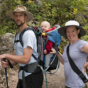
We left early on Friday afternoon, and secured an excellent, large campsite at the Elbert Creek NF campground. We would end up with 11 people in our group, 7 tents and 4 cars on the site, and we were all right across the street from the trailhead. Even though we drove through some rain and clouds on the way to the site, it was dry during the evening and night. Due to camping at 10,000ft, some of the people in the group had a little trouble sleeping, and one person swore he heard a bear in the middle of the night. Mark and I were happy and comfy all the way until the alarm went off at 5am the next morning.

100_0041

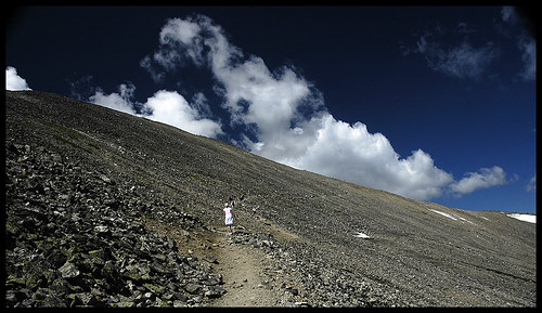
We hit the trail just before dawn, at around 5:45am. There were already quite a few cars in the parking lot, and Liv got into a barking match with about 4 other dogs. The first two miles of trail are pretty steep, and intensely “up”. There is very little “down”. At around 8am, we hit tree line, and already we could see clouds heading into our area.

100_0048

We continued hiking up the trail, listening for thunder or signs of increasing convection. Thick, low, stratiform clouds are often cold and annoying but rarely as dangerous as the afternoon monsoonal storms that blow through Colorado. We had heard from many sources that, per the usual, strong storms were forcast for the afternoon, so we wanted to make it back to treeline by 12pm.

100_0057

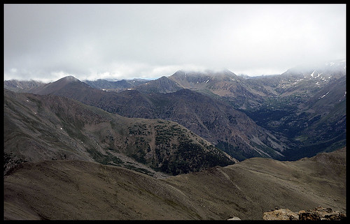
By 12,000ft (8:45am) we were fully engulfed in the cloud. This was disappointing for everybody in the group. The best part of hiking the 14ers in Colorado is always the incredible view. In our case last weekend, there was absolutely no view. Of course, Mark and I didn’t break out the GPS to see what our altitude was, we figured we’d just be able to see the top as we got closer. However, Mt. Elbert is known for it’s three false summits. We’d hike through the cloud, see the shape of a tall ridge above us… that must be the summit! Hike up there quickly… and see the shape of another tall ridge above us. Three times this happend. As I stood on the third false summit looking at another dim outline of a ridge in the cloud above me, I really wanted to just turn back.

100_0063

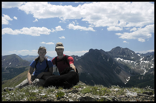
But Liv and Mark both wanted to go on, and, whaddya know!?, that last ridge was the summit ridge. At 10:24am on Saturday, August 5, Mark, Liv, many of our friends, and I stood on top of the highest point in Colorado. Too bad about that view.

I was really proud to be up there. The clouds had freaked me out. I had been really scared for much of the last 1,500ft of climbing because the thick white blanket around us was so disorienting. I was worried about lightening and poor visibility. But none of those were real threats, and I pushed my fear aside and summited! Mark was exhausted. We had set a hard pace in thin air, and he just wanted to sit down and take a nap.

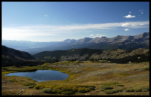
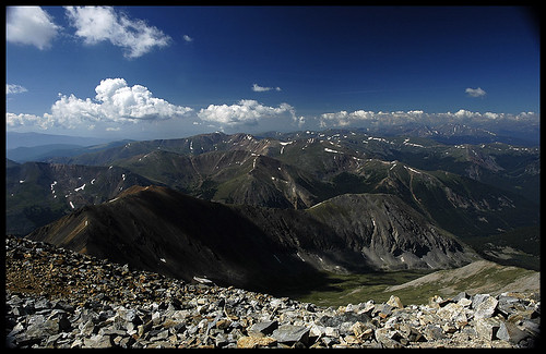
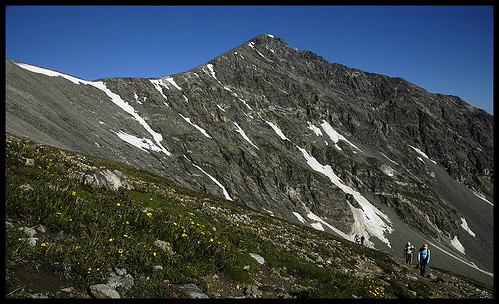
But we had 2 miles and well over 2,000ft of descending to get back to treeline, and that was going to be tricky to make in an hour and half. So we took some pictures and headed home. On the way down the mountain, of course, we popped out of the bottom of the clouds before we even reached 13,500ft. We found out later that two of our friends who summited about 30 minutes after us got a view from the top! Lucky.

DSC5259

The trip back down was surprisingly painful. Even with my trekking pole and light backpack, my knees and hips were killing me after only 30 minutes of hiking. We still had to stop fairly frequently on the way down to let our joints recuperate. Boy, getting old sucks. Even Liv was walking far slower on the way down than she had been on the way up.

In the last .25 miles, we heard a roll of thunder and a few raindrops started splattering down. We dug deep and jogged back to the campground, making it to the cover of the dining tarp the instant it started pouring rain. Perfect timing. Unfortunatley, the rain didn’t seem to be letting up, and after an hour or so, everybody decided to pack up and head home. Camping in the rain is no fun. We cleaned everything up and drove back to Fort Collins that night.

Great weekend, awesome hike, amazing accomplishement, and good company!!

Cloudy morning in the Sawatch

August 8, 2006 at 8:54 am

Yes, I know, it’s been a while since my last posting! Last weekend we traveled south to Leadville, CO and spent the weekend camping and hiking Mt. Elbert. At 14,436ft tall, this is the highest peak in Colorado. And Mark and I bagged it! Woo-hoo!

Unfortunately, it was a very wet day, with clouds moving into the area by 8:30 am. Most of our hike on the way up was totally closed in by clouds, and there was absolutely no view at all from the top off the mountain. Oh well, at least we can say we stood at the highest point in a very high and pointy state!

More pictures will follow this one, and I’ll set up a gallery soon. For now, the shot below is from our hike down, after popping out the bottom of the cloud. It’s a view of Mt Massive (the 2nd tallest peak in CO) from the upper slopes of Mt Elbert. Sawatch range, Colorado.


Summit View

July 27, 2006 at 8:57 am

Looking Southwest off the summit of Gray’s Peak at the Sawatch Range. If the shot were a little more to the right (west) you would see A-Basin, Keystone, Dillion and Dillon Reservoir. We thought that was pretty cool.


Upper slopes of Grays Peak

July 26, 2006 at 7:30 am

This is a shot from the upper slopes of Grays. The trail was relatively easy, definately well defined. It switch-backed all the way up the face, and you can see little people all along the horizon if you view this large (click the image to get to flickr). I actually took this picture on our way down, just before 11am or so. There were plenty of people working their way up the mountain still, even though the clouds had started to move in a bit.

In the mountains during the summer, serious afternoon thunderstorms (heavy rain, wind, hail and much lightening) are very common. This day was after a frontal system had moved through, so an area of substinace and upper level dry air were preventing deep convection from occuring. Still, it made for some pretty clouds in the afternoon.


Climbing Gray’s Peak

July 25, 2006 at 7:12 pm

Last Saturday, Mark and I sucessfully climbed Gray’s Peak. At 14,270ft (or so) it is usually listed as the 9th tallest peak in Colorado. I thought about writing up a nice trip report for this one, but I have a problem. You see, nothing really exciting happend. Mark and I have been soooo lucky this summer to have trips blissfully free of drama. This is fun and happy for us, but boring for you, the readers!

So, here is the basic synopsis of the trip. We left Fort Collins at around 5:30pm on Friday night, and arrived at the trailhead around 8:00pm. As the trail and trailhead are on National Forest land, we simply found a flat(ish) spot, set the tent up, and headed to bed. Unfortunately, we were trying to sleep on a hillside at 11,300ft, and neither Mark nor I were very sucessful. Oh well. The next morning, we woke at 5:30am, and walked across the parking lot to the trail by 5:45 or so. We hiked the 3.5 miles to the summit (about 3,000ft elevation gain) slowly and carefully. We summited around 9:45. Pictures all around!! The option to continue on to Torrey’s summit was very tempting, but we all felt tired and the idea of “more up” just wasn’t appealing. We started down at around 10:30 am. Made it back to the parking lot by 12:30pm or so. I did not get sick or feel faint on the way down as I have on previous trips, though I did develop a pounding headache about a half mile out from the parking lot. Two advil, a cream soda, a hard-boiled egg, and half a bag of chex-mix later, and Mark and I were packed up, in the car and headed back down to home.

A beautiful hike, an incredible summit, a perfect weather kind of day, and I got some nice shots. You’ll see quite a few of them here, I think!


Wild Columbine Near the Trail

July 21, 2006 at 9:50 am

Well, I finally got all the pictures up from the Thayer Family Vacation (click here!) and also the pictures from our really beautiful hike up North and South Diamond Peaks near Cameron Pass (click here too!).

This is another shot from that hike. The wild columbine is the state flower of Colorado, but it’s also sometimes considered an endangered flower. Supposedly, it’s protected such that it’s illegal to pick wild-growing columbine. I had never seen as many bushes of this flower growing wild on one mountain as we saw on the Diamond Peaks. It was all over the place. And absolutely beautiful.


Summit Photo!

July 18, 2006 at 6:07 pm

Portrait of the family (the hubby, the dog and me) on the beautiful and flower-covered summit of North Diamond Peak. Too bad we never did get the dog to turn around and face the camera. I think she was getting tired.

I took a boat-load of fantastic photos from this hike, and I hope to be able to blog a good chunk of them. I will also add a gallery at some point, check back for a link when I get that done.

Rawahs, Colorado, July 2006.