Monday was the last day in our long weekend, and Mark and I wanted to make another summit bid for the top of Mt. Yale (14,196ft). We tried to climb this mountain on a backpacking trip in May, but it was too cold and windy on top, and we turned around at 13,000ft. (Note: You can find all of the shots from this weekend in the photo gallery.)
The night before the hike, we got all of our daypacks ready, and then decided to pack up the camp into the plastic storage bins we use and just sleep in the car for the night. What seemed like a great idea really wasn’t, as neither one of us could get comfortable enough to get much sleep at all that night. So, when the alarm went off at 5:30am, I opted for another half hour of snoozing. Thus, we didn’t actually get on the trail until about 6:45 in the morning.

A climb of Mt. Yale via the southwest slopes (as we hiked) is about 7 miles round-trip according to the guidebooks. Thus, the climb to the summit is only 3.5 milels from the car, not bad, right? Well, it turns out the parking lot is below 10,000ft, so the trail climbs well over 4,000ft in 3.5 miles. Yes, it’s steep. It’s steep the whole way. There are very few flat parts, and no breaks. That’s an average gradient of almost 25% at an altitude where walking on flat ground will leave most people gasping for air.

The last 200ft of the climb involves an exciting and somewhat exposed 2nd class scramble over large boulders on a rather thin ridgeline. Liv had a great time on this until the middle crux section, where she found herself on some dicy vertical ground that was starting to look 3rd class. We spent about 20 minutes scrambling around trying to find the safest and easiest way to get past this section. There were “trails” (areas with dirt between rocks) all over the place, and cairns that lead off in several different directions. We decided to head down low and left of the ridgeline and even though we decreased the technical grade of the climb, the seriously loose rock we scrambled across greatly increased the excitement of the climb.
Liv made it just fine through this area, and we made it to the summit at just before 11:30am, and thanks to my spiffy new altimeter watch, I could see the temperature was 69F and the barometric pressure was 604mb.

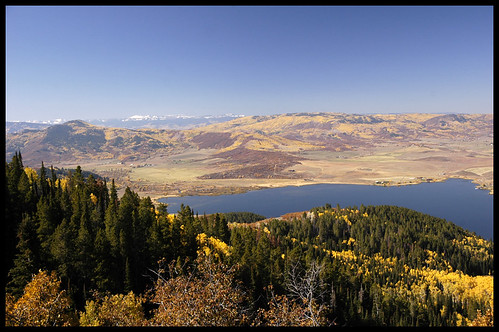
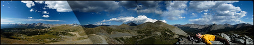
The view from the summit was incredible. The sky was perfectly clear and blue. People kept telling us that we could see 30 other 14ers (out of 54 in the state) from the summit. I believed them. You could definately see the unmistakable outline of Pikes Peak which was over 100 miles to the east.

On the way down, we followed another couple of climbers and discovered the correct trail back. It involved an easy but hidden traverse on what would have been the right side of the ridge. The rock was much more solid on the way down, and all three of us (including the dog) had a much more fun time with this scramble.

The trip down the slopes was just as steep as it had been on the way up, and I found myself sliding down a dirt hill on my butt more times than once. Mark managed to really finish off the sunburn he had started on the previous day, and was rather miserable by the afternoon. We reached the car at the trailhead around 3pm, ate a big snack, piled everything back in the car and drove home.