Colorado National Monument TR (Part II)
More shots are up in the gallery!
Sunday morning dawned warm and bright in the desert campground. We had spent time the night before re-racking, re-packing, and re-filling water for the day’s activities, so all we need to do on Sunday morning was pack up the tent, make coffee and then hop on the trail!
We were back at the Independence Monument trailhead at around 8:30am, way earlier than I ever expected. Mark was worried about another large group getting on the tower before us, so we were happy to see that nobody else had signed on the trail register yet that morning. These indications where happily confirmed when we found ourselves to be the first ones at the base of the climb that morning. Yey!
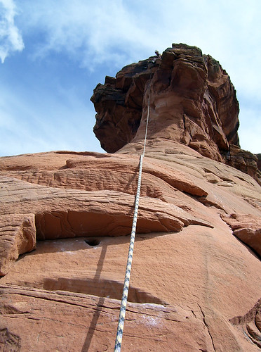
Our climb for the day was Otto’s Route (5.8), which is a historic route, the first ever to the top of Independence Monument. John Otto climbed the route for the first time in 1911, and, in order to make the route do-able, he carved foot steps and handholds into the soft sandstone all the way up the route. Mark and I had heard of these added pockets, and thought they would soften the grade. However, it turns out that Mr Otto was, evidently, seven and half feet tall and regularly solo’d V18 or so. The climb was hard. It really was.
Pitch 1: A long and sandy ramp, that was trickier than I expected. Mark took quite a while to lead this, and he kept calling down “I’m at a big ledge, should I set a belay??” “No… look for chains!” I was going to give him trouble about taking so long to lead a 5.5 ramp, but then I fell twice on my way up when my feet slid off the sandy rock.
Pitch 2: A quick scramble around the corner, and then we’re into the early crux of the climb, an overhanging off-fists crack where a huge boulder rests against the wall. Mark pro’d it well with a blue and silver camalot, and then did the classic Ved ‘one leg in, hump your way up’ ascent. It was intimidating for me too, but I found a critical drilled pocket, and then wedged my leg high enough that I could scramble over the top fairly easily.
Pitch 3: This pitch started with a scramble over a stack of boulders, and then you hike up the ramp behind the huge flake in what the topos call the “time tunnel”. Once back out into the sun, we climbed a face with a few pockets, and some sandy ledges up to the big ledge below the final pitch. It was another pitch that seemed like it should have been easier than it felt as I was climbing it.
Pitch 4: The final, exposed, crux-a-liscious pitch. We walked around to the far side of the tower and then walked up the easy, but completely unprotectable face. I had seen shots on MP.com that looked like there was pro somewhere up there, but Mark just couldn’t find it. After 100ft of this scary stuff, the wall starts to get vertical. Two or three moves brings you to the first of three pitons that protect the final overhang. This overhang was tough. It was long, maybe 15-20 ft of climbing, and by the time I was reaching for the top, I was massively freaked out, and my hands were so tired they were involuntarily opening as I tried to grab the sloped ledges. Yes, I did hang a bit, but I flopped onto the ledge eventually.
We sat on the ledge for a while and caught our breath. The summit was up a 7ft holdless headwall, well above the anchors, and we weren’t sure how to get up there. We decided to start our rappels down rather than boulder this unprotected 400ft in the air. But the couple climbing up below us caught sight of our ropes and convinced us that if we just stayed put for a few minutes, they’d be up there and could show us how to get on top. “You want to get to the top after all of this work, right??” They yelled up.
So Jessie and Margaret met us at the final belay. Jessie was kind enough to share his water, which I somehow stupidly forgot on the ground. They were both local Grand Junction climbers out for Margaret’s first lead of this classic route. She did awesome. Jessie showed us the trick was to take a loooong rope leash (like 20ft), and then scramble up over the lip using some holds on the left side (and standing on the metal tube that was embedded in the rock). He spotted all of us on the way up, and then belayed us down, these guys were my heros. Getting to the actual top was great, and I don’t think I would have enjoyed the climb nearly as much without their help at the end.
Descent: In order to avoid having to dig out our two extra, coiled and packed away ropes, we all four agreed to just tie our lead lines together for the two double rope rappels required to get off the rock. We rapped over the edge from the top anchors, down through the time tunnel, all the way to the second belay. These were both two of the longest, most vertical rappels I’ve done in a long time. It was good practice for our up-coming weekend at Devil’s Tower, though. There was some confusion as to whether or not two 60m ropes would reach the ground from the second belay, but Margaret and I felt they should, and Jessie agreed to be the guinea pig. They did make it all the way down, with about 2ft of rope on the ground at the end. Don’t tie your knots with too much rope for this one!
It felt really good to be back on the ground, and kind of funny to see the conga-line of climbers working their way up the lower pitches. Yep, it’s definitely a popular route. We hung out for a little while, repacking, eating, drinking and talking with Jessie and Margaret about climbing areas in the desert and the Front Range. There were clouds moving in, and Mark and I had to make it back to Denver that night, so we couldn’t spend too long relaxing.
The hike back went quickly, though we did stop to check out a giant blue lizard, and had to spend some time throwing rocks at a pretty big desert gopher snake to get it off the trail. We were supposed to pick up Mom at the airport on Monday morning, so we drove back to Denver, and holed up at a KOA near the airport for a night of exhausted sleep. Good weekend!


5 Comments