Mt. Yale Movie

September 15, 2006 at 6:17 pm

Well, I thought I would try something kind of cool tonight, and see if I can get this movie to work within this post. If I can get it here, than I can start posting them in different areas of the site. The movie is a little bit large still, so give it a minute and it will eventually load.

Yes, if you listen closely, you can hear Mark saying “I want jalapeno poppers!”

Buena Vista Weekend TR (part II)

September 15, 2006 at 8:59 am

Monday was the last day in our long weekend, and Mark and I wanted to make another summit bid for the top of Mt. Yale (14,196ft). We tried to climb this mountain on a backpacking trip in May, but it was too cold and windy on top, and we turned around at 13,000ft. (Note: You can find all of the shots from this weekend in the photo gallery.)

The night before the hike, we got all of our daypacks ready, and then decided to pack up the camp into the plastic storage bins we use and just sleep in the car for the night. What seemed like a great idea really wasn’t, as neither one of us could get comfortable enough to get much sleep at all that night. So, when the alarm went off at 5:30am, I opted for another half hour of snoozing. Thus, we didn’t actually get on the trail until about 6:45 in the morning.
DSC5439

A climb of Mt. Yale via the southwest slopes (as we hiked) is about 7 miles round-trip according to the guidebooks. Thus, the climb to the summit is only 3.5 milels from the car, not bad, right? Well, it turns out the parking lot is below 10,000ft, so the trail climbs well over 4,000ft in 3.5 miles. Yes, it’s steep. It’s steep the whole way. There are very few flat parts, and no breaks. That’s an average gradient of almost 25% at an altitude where walking on flat ground will leave most people gasping for air.

DSC5443_2

The last 200ft of the climb involves an exciting and somewhat exposed 2nd class scramble over large boulders on a rather thin ridgeline. Liv had a great time on this until the middle crux section, where she found herself on some dicy vertical ground that was starting to look 3rd class. We spent about 20 minutes scrambling around trying to find the safest and easiest way to get past this section. There were “trails” (areas with dirt between rocks) all over the place, and cairns that lead off in several different directions. We decided to head down low and left of the ridgeline and even though we decreased the technical grade of the climb, the seriously loose rock we scrambled across greatly increased the excitement of the climb.

Liv made it just fine through this area, and we made it to the summit at just before 11:30am, and thanks to my spiffy new altimeter watch, I could see the temperature was 69F and the barometric pressure was 604mb.

DSC5457

The view from the summit was incredible. The sky was perfectly clear and blue. People kept telling us that we could see 30 other 14ers (out of 54 in the state) from the summit. I believed them. You could definately see the unmistakable outline of Pikes Peak which was over 100 miles to the east.

DSC5450

On the way down, we followed another couple of climbers and discovered the correct trail back. It involved an easy but hidden traverse on what would have been the right side of the ridge. The rock was much more solid on the way down, and all three of us (including the dog) had a much more fun time with this scramble.

DSC5460

The trip down the slopes was just as steep as it had been on the way up, and I found myself sliding down a dirt hill on my butt more times than once. Mark managed to really finish off the sunburn he had started on the previous day, and was rather miserable by the afternoon. We reached the car at the trailhead around 3pm, ate a big snack, piled everything back in the car and drove home.

Buena Vista Weekend TR (part I)

September 13, 2006 at 10:22 am

What do you do with a long weekend in Colorado? Road trip! It was definately time to head back to the high peaks, and Mark and I picked the quiet mountain town of Buena Vista, CO for the three sunny days at the beginning of September.

(Note: You can find all of the shots from the weekend in the photo gallery.)

We left on Saturday morning, and drove the long way out. We drove south through Breckenridge, over Hoosier Pass, and came upon Buena Vista from the southeast side.

DSC5350

After driving around town a bit looking for a climbing guide, we headed up Cottonwood Pass road to find a campsite. Unfortunately, the national forest campground I had been hoping to stay at was completely booked. However, we did find a nice little free site in a deep grove of aspens just off the road. No bathrooms or picnic tables for us on this trip, but at least we weren’t paying for it either.

DSC5355

Mark grilled steaks that had been marinating in our cooler all day for dinner… and it was fantastic.

Sunday morning we slept in. We made a big breakfast of chorizo, pepper, onion and egg burritos and then packed up and headed out to climb for the day. I had read a little about the Buena Vista Crags on the internet, and gotten a guidebook at a local shop the afternoon before. The crags turned out to be really cool. Huge, well bolted, boulders on the east side of the valley, with gorgious views of the Collegiate Peaks and the town below.

DSC5393

Mark and I spent the afternoon enjoying nice, moderate sport climbing. Unfortunately, the sunscreen we had both used in the morning had, evidently, stopped working after I used it. And Mark got the strong foundation of a really nasty sunburn on his neck and shoulders that afternoon. Just for future reference, we climbed at Transmitter Tower and ticked off 3 fun moderates.

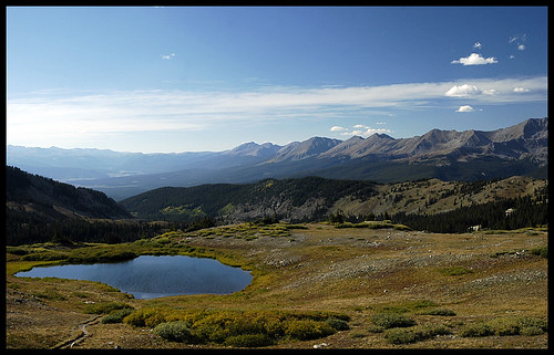
In the evening, we decided to drive past our campsite, and travel all the way up the road to Cottonwood Pass. This turned out to be an incredible place. Absolutely some of the most incredible mountain scenery I’ve ever seen from within a half mile of our car. On the east side of the pass, you had fantastic views of the Sawatch and Collegiate Peaks. On the west side were the dark, imposing peaks in the Gunnison, and the Elk mountains beyond.

DSC5412
DSC5414

I could have stayed there all evening, it was incredibly beautiful. But, we had burgers to grill before dark, and preparations to make before the Big Hike on monday: a summit bid for Mt Yale (next in Part II).

Cottonwood Pass

September 9, 2006 at 6:26 am

Well, looks like I should carry a tripod around with me more often if I really want to be able to shoot panoramas like this one. I played with it in photoshop for quite a while, but really what would have helped is holding the camera straight!

Still, I have to say, this was one of the absolutely most beautiful places I have ever been. I highly recommend spending time in Buena Vista if you ever travel to Colorado.

Definately check out the origional sized image, to see the whole goodness.


Looking west from Cottonwood Pass

September 7, 2006 at 6:53 pm

Another shot from the long weekend. I’m working through the pictures pretty quickly, but not quite ready for the full trip report yet. Enjoy the picture! This is a shot looking into the Gunninson National Forest in southern Colorado. What a fantastic place. West of Buena Vista, CO, at 12,100ft. September 2006.


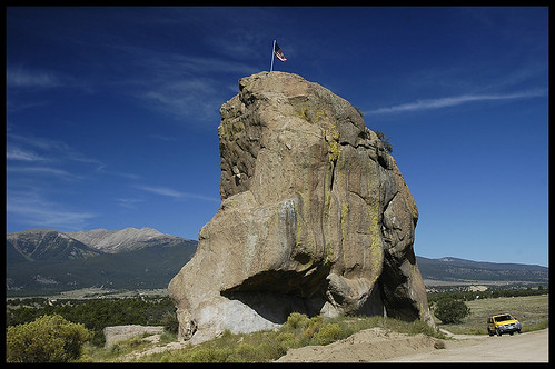
Bob’s Rock

September 6, 2006 at 7:35 pm

Sorry it’s been so long, August just blew right by me! Mark and I have been mountain biking a lot in the last couple of the weeks. Partly because we’ve had some cruddy, rainy weekends (good for mountain biking though!) and partly because I’m racing in the Beaver Meadows Mania MTB race next weekend! Wish me luck… and expect more pictures this week!

This shot is from our long weekend in Buena Vista. I am really starting to love this place. I’ll put together a trip report once the photos are finished. For now, this is a hokey picture, but I like it. That’s my little yellow truck! Buena Vista, CO. September 2006.


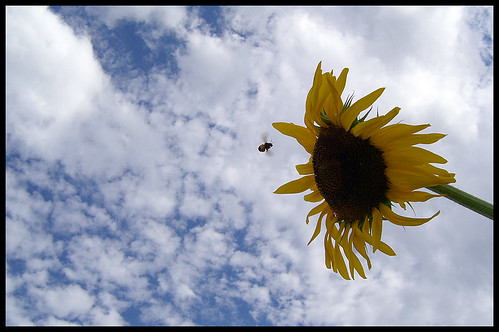
Get out of my picture, Bee!

August 12, 2006 at 4:17 pm

Well, we had another rainy Saturday today! I just can’t believe it’s been wet two weekends in a row!! We got in a great climb at Vedauwoo before it got too wet, and Mark took some pictures so I might post one of those tomorrow.

For now, this is a shot from a dog walk last week. We have a communal garden in our neighborhood, and sunflowers seem to be popular crops. I tried to take a picture of the flower and clouds several times, and the bee just wouldn’t get out of the frame! When I finally looked at the pictures on the computer, I think it’s not so bad any more.


Mt. Elbert Trip Report

August 11, 2006 at 12:42 pm

Last weekend, Mark and I got a big group of friends to go all the way down into the Sawatch range near Leadville, CO to climb the tallest peak in the state: Mt. Elbert. (You can find the full gallery of images here: http://colocalders.com/photos) The hike was only about 9 miles round trip, and only class I, but with an elevation gain of 4,428ft and much of the last 2 miles being above 11,000ft, it was a long, hard haul.

We left early on Friday afternoon, and secured an excellent, large campsite at the Elbert Creek NF campground. We would end up with 11 people in our group, 7 tents and 4 cars on the site, and we were all right across the street from the trailhead. Even though we drove through some rain and clouds on the way to the site, it was dry during the evening and night. Due to camping at 10,000ft, some of the people in the group had a little trouble sleeping, and one person swore he heard a bear in the middle of the night. Mark and I were happy and comfy all the way until the alarm went off at 5am the next morning.

100_0041

We hit the trail just before dawn, at around 5:45am. There were already quite a few cars in the parking lot, and Liv got into a barking match with about 4 other dogs. The first two miles of trail are pretty steep, and intensely “up”. There is very little “down”. At around 8am, we hit tree line, and already we could see clouds heading into our area.

100_0048

We continued hiking up the trail, listening for thunder or signs of increasing convection. Thick, low, stratiform clouds are often cold and annoying but rarely as dangerous as the afternoon monsoonal storms that blow through Colorado. We had heard from many sources that, per the usual, strong storms were forcast for the afternoon, so we wanted to make it back to treeline by 12pm.

100_0057

By 12,000ft (8:45am) we were fully engulfed in the cloud. This was disappointing for everybody in the group. The best part of hiking the 14ers in Colorado is always the incredible view. In our case last weekend, there was absolutely no view. Of course, Mark and I didn’t break out the GPS to see what our altitude was, we figured we’d just be able to see the top as we got closer. However, Mt. Elbert is known for it’s three false summits. We’d hike through the cloud, see the shape of a tall ridge above us… that must be the summit! Hike up there quickly… and see the shape of another tall ridge above us. Three times this happend. As I stood on the third false summit looking at another dim outline of a ridge in the cloud above me, I really wanted to just turn back.

100_0063

But Liv and Mark both wanted to go on, and, whaddya know!?, that last ridge was the summit ridge. At 10:24am on Saturday, August 5, Mark, Liv, many of our friends, and I stood on top of the highest point in Colorado. Too bad about that view.

I was really proud to be up there. The clouds had freaked me out. I had been really scared for much of the last 1,500ft of climbing because the thick white blanket around us was so disorienting. I was worried about lightening and poor visibility. But none of those were real threats, and I pushed my fear aside and summited! Mark was exhausted. We had set a hard pace in thin air, and he just wanted to sit down and take a nap.

But we had 2 miles and well over 2,000ft of descending to get back to treeline, and that was going to be tricky to make in an hour and half. So we took some pictures and headed home. On the way down the mountain, of course, we popped out of the bottom of the clouds before we even reached 13,500ft. We found out later that two of our friends who summited about 30 minutes after us got a view from the top! Lucky.

DSC5259

The trip back down was surprisingly painful. Even with my trekking pole and light backpack, my knees and hips were killing me after only 30 minutes of hiking. We still had to stop fairly frequently on the way down to let our joints recuperate. Boy, getting old sucks. Even Liv was walking far slower on the way down than she had been on the way up.

In the last .25 miles, we heard a roll of thunder and a few raindrops started splattering down. We dug deep and jogged back to the campground, making it to the cover of the dining tarp the instant it started pouring rain. Perfect timing. Unfortunatley, the rain didn’t seem to be letting up, and after an hour or so, everybody decided to pack up and head home. Camping in the rain is no fun. We cleaned everything up and drove back to Fort Collins that night.

Great weekend, awesome hike, amazing accomplishement, and good company!!